Navigation systems for heavy lift carriers

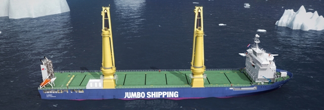
Drawing of a K-3000 heavy lift carrier for Jumbo Shipping Photo: Jumbo Shipping
The 152m-long vessels with a lifting capacity of 3,000 tonnes are designed for offshore operations even in icy waters. Delivery of both vessels is scheduled for 2013. The installed INS includes S-band and X-band radar sensors, configured as full wide-screen multifunctional workstations for chart radar, radar, ECDIS and conning. According to Raytheon Anschütz, two additional multifunctional workstations with the same configuration serve as main and backup ECDIS, and another multifunctional workstation with ECDIS and conning function is supplied for route planning purposes. Additionally, the bridge is equipped with two fixed-role conning displays. Within the INS, all workstations are connected through a redundant ethernet-based local area network (LAN). Relevant navigation data such as charts, routes and sensor information are shared within the network and stored independently on each system. Thereby, the integrated consistent common reference system (CCRS) monitors all navigation sensors selects the best available data. The conning also includes a new page for central alert monitoring and the intelligent handling and processing of alarms, warnings and cautions within a centralised alert management system is said to help avoiding unnecessary multiple alerts on the bridge. For manual and automatic steering control, Raytheon Anschütz provides equipment from its NautoSteer AS series based on CAN-bus technology and providing functionalities such as integrated steering failure, wire-break monitoring and a simplified steering mode selector switch as well as the adaptive NautoPilot 5300.
