REMUS 600 AUV contracted
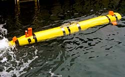
The REMUS 600 will be used to conduct surveys in navigable waters in port, harbour, and coastal environments
28. October 2011
| Editorial staff Ship&Offshore
The REMUS 600 will provide NOAA's Office of Coast Survey with full bottom coverage depth sounding data in conformance with NOAA standards for nautical charting.
The REMUS 600 will be used to conduct surveys in navigable waters in port, harbor, and coastal environments. Coast Survey is responsible for acquiring hydrographic data for NOAA's nautical charting program, which provides navigational products and services for the maritime industry and recreational boaters.